
Heungdeok-gu topographic map
Interactive map
Click on the map to display elevation.
About this map
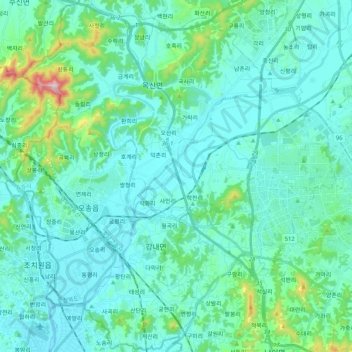
Name: Heungdeok-gu topographic map, elevation, terrain.
Location: Heungdeok-gu, Cheongju-si, North Chungcheong, South Korea (36.56176 127.27560 36.72467 127.48193)
Average elevation: 243 ft
Minimum elevation: 52 ft
Maximum elevation: 1,424 ft
Other topographic maps
Click on a map to view its topography, its elevation and its terrain.
Cheongwon-gu
Cheongwon-gu, Cheongju-si, North Chungcheong, South Korea
Average elevation: 443 ft
Sangdang-gu
Sangdang-gu, Cheongju-si, North Chungcheong, South Korea
Average elevation: 541 ft