
Glafki topographic map
Interactive map
Click on the map to display elevation.
About this map
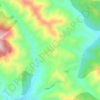
Name: Glafki topographic map, elevation, terrain.
Average elevation: 1,686 ft
Minimum elevation: 1,043 ft
Maximum elevation: 2,828 ft
Other topographic maps
Click on a map to view its topography, its elevation and its terrain.
Olvio
Greece > Macedonia and Thrace > Xanthi Regional Unit
Olvio, Topeiros Municipality, Xanthi Regional Unit, Eastern Macedonia and Thrace, Macedonia and Thrace, 672 00, Greece
Average elevation: 102 ft
Xanthi
Greece > Macedonia and Thrace > Xanthi Regional Unit
Xanthi, Xanthi Municipal Unit, Xanthi Municipality, Xanthi Regional Unit, Eastern Macedonia and Thrace, Macedonia and Thrace, 671 00, Greece
Average elevation: 1,020 ft