
Siddipet topographic map
Interactive map
Click on the map to display elevation.
About this map
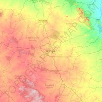
Name: Siddipet topographic map, elevation, terrain.
Average elevation: 1,565 ft
Minimum elevation: 1,079 ft
Maximum elevation: 2,021 ft
Other topographic maps
Click on a map to view its topography, its elevation and its terrain.
Gandhigram(B.C Colony)
India > Telangana > Siddipet_Urban mandal > Siddipet > Gandhigram(B.C Colony)
Gandhigram(B.C Colony), Siddipet, Siddipet_Urban mandal, Siddipet, Telangana, 502 103, India
Average elevation: 1,634 ft