
Kirkton of Tough topographic map
Interactive map
Click on the map to display elevation.
About this map
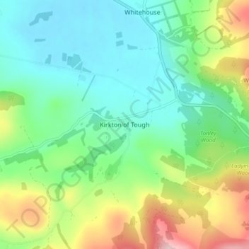
Name: Kirkton of Tough topographic map, elevation, terrain.
Average elevation: 689 ft
Minimum elevation: 430 ft
Maximum elevation: 1,280 ft
Other topographic maps
Click on a map to view its topography, its elevation and its terrain.
Crathie
United Kingdom > Scotland > Aberdeenshire
Crathie, Aberdeenshire, Scotland, AB35 5UL, United Kingdom
Average elevation: 1,178 ft
East Mains
United Kingdom > Scotland > Aberdeenshire > Banchory
East Mains, Banchory, Aberdeenshire, Scotland, AB31 4BG, United Kingdom
Average elevation: 325 ft
Braemar
United Kingdom > Scotland > Aberdeenshire
Braemar, Aberdeenshire, Scotland, AB35 5YN, United Kingdom
Average elevation: 1,460 ft
Findon
United Kingdom > Scotland > Aberdeenshire > Findon
Findon, Aberdeenshire, Scotland, AB12 3RP, United Kingdom
Average elevation: 148 ft
Peterhead
United Kingdom > Scotland > Aberdeenshire
Peterhead, Aberdeenshire, Scotland, AB42 1ZP, United Kingdom
Average elevation: 56 ft
Huntly
United Kingdom > Scotland > Aberdeenshire
Huntly, Aberdeenshire, Scotland, AB54 8AE, United Kingdom
Average elevation: 561 ft
Redstone Hill
United Kingdom > Scotland > Aberdeenshire
Redstone Hill, Aberdeenshire, Scotland, AB30 1HB, United Kingdom
Average elevation: 1,004 ft