
Steingaden topographic map
Interactive map
Click on the map to display elevation.
About this map
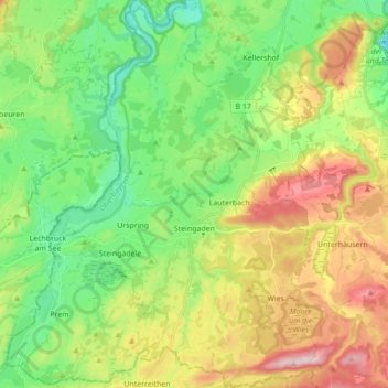
Name: Steingaden topographic map, elevation, terrain.
Average elevation: 2,618 ft
Minimum elevation: 2,208 ft
Maximum elevation: 3,310 ft
Other topographic maps
Click on a map to view its topography, its elevation and its terrain.
Feuchten
Duitsland > Beieren > Landkreis Weilheim-Schongau > Forst
Feuchten, Forst, Wessobrunn, Landkreis Weilheim-Schongau, Beieren, 82405, Duitsland
Average elevation: 2,300 ft
Raisting
Duitsland > Beieren > Landkreis Weilheim-Schongau
Raisting, Landkreis Weilheim-Schongau, Beieren, 82399, Duitsland
Average elevation: 1,847 ft