
Make a donation
Gear up for your next adventure:
As an Amazon Associate, this site earns from qualifying purchases at no extra cost to you.
Inwood topographic map
Click on the map to display elevation.
Make a donation
Gear up for your next adventure:
As an Amazon Associate, this site earns from qualifying purchases at no extra cost to you.
About this map
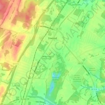
Name: Inwood topographic map, elevation, terrain.
Location: Inwood, Berkeley County, West Virginia, United States (39.33764 -78.08216 39.36677 -78.02825)
Average elevation: 577 ft
Minimum elevation: 443 ft
Maximum elevation: 712 ft
Berkeley County trails, hiking, mountain biking, running and outdoor activities
Make a donation
Gear up for your next adventure:
As an Amazon Associate, this site earns from qualifying purchases at no extra cost to you.
Other topographic maps
Click on a map to view its topography, its elevation and its terrain.
Make a donation
Gear up for your next adventure:
As an Amazon Associate, this site earns from qualifying purchases at no extra cost to you.
West Martinsburg Historic District
United States > West Virginia > Berkeley County > Martinsburg > Rosemont
Average elevation: 489 ft
Berkeley Place
United States > West Virginia > Berkeley County > Martinsburg > Berkeley Place
Average elevation: 466 ft