
Kumara topographic map
Interactive map
Click on the map to display elevation.
About this map
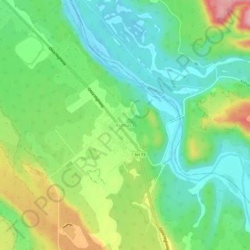
Name: Kumara topographic map, elevation, terrain.
Location: Kumara, Westland District, West Coast, 7832, New Zealand (-42.64987 171.16691 -42.60987 171.20691)
Average elevation: 240 ft
Minimum elevation: 46 ft
Maximum elevation: 607 ft
Other topographic maps
Click on a map to view its topography, its elevation and its terrain.
Kapitea Reservoir
Kapitea Reservoir, Duffers Creek Road, Kumara, Westland District, West Coast, 7832, New Zealand
Average elevation: 479 ft