
Make a donation
Gear up for your next adventure:
As an Amazon Associate, this site earns from qualifying purchases at no extra cost to you.
Ayder topographic map
Click on the map to display elevation.
Make a donation
Gear up for your next adventure:
As an Amazon Associate, this site earns from qualifying purchases at no extra cost to you.
Ayder
Ayder at 40°57′N 41°05′E / 40.950°N 41.083°E / 40.950; 41.083 is a typical yayla with no settled population; it hosts visitors during summers. The average altitude is 1,350 metres (4,430 ft). It is a part of Çamlıhemşin District of Rize Province. The distance to Çamlıhemşin is 17 kilometres (11 mi) and to Rize is 88 kilometres (55 mi).
Make a donation
Gear up for your next adventure:
As an Amazon Associate, this site earns from qualifying purchases at no extra cost to you.
About this map
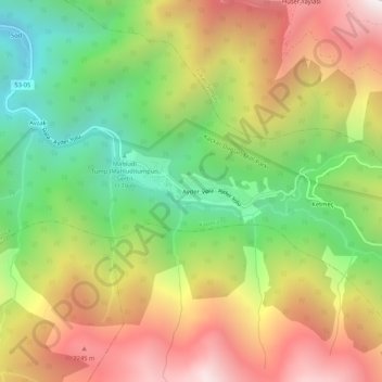
Name: Ayder topographic map, elevation, terrain.
Average elevation: 5,522 ft
Minimum elevation: 3,071 ft
Maximum elevation: 8,291 ft
Make a donation
Gear up for your next adventure:
As an Amazon Associate, this site earns from qualifying purchases at no extra cost to you.
Other topographic maps
Click on a map to view its topography, its elevation and its terrain.
Make a donation
Gear up for your next adventure:
As an Amazon Associate, this site earns from qualifying purchases at no extra cost to you.