
Trosa kommun topographic map
Interactive map
Click on the map to display elevation.
About this map
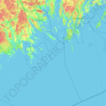
Name: Trosa kommun topographic map, elevation, terrain.
Location: Trosa kommun, Södermanland County, Region Svealand, Sweden (58.46785 17.35600 58.99500 17.95441)
Average elevation: 23 ft
Minimum elevation: -3 ft
Maximum elevation: 266 ft
Other topographic maps
Click on a map to view its topography, its elevation and its terrain.
Bromma
Bromma, Vingåkers kommun, Södermanland County, Region Svealand, Sweden
Average elevation: 167 ft
Oxelösunds kommun
Oxelösunds kommun, Södermanland County, Region Svealand, Sweden
Average elevation: 7 ft
Vithälla
Sweden > Södermanland County > Vithälla
Vithälla, Nyköping, Södermanland County, Region Svealand, 611 92, Sweden
Average elevation: 115 ft
Katrineholm
Katrineholm, Sveriges Landskap, Södermanland County, Region Svealand, Sweden
Average elevation: 164 ft
Skogsbyås
Sweden > Södermanland County > Bråten
Skogsbyås, Bråten, Nyköping, Södermanland County, Region Svealand, Sweden
Average elevation: 266 ft
Stenkullen
Stenkullen, Katrineholm, Södermanland County, Region Svealand, Sweden
Average elevation: 154 ft