Geolocate

Riemst topographic map

Click on the map to display elevation.

About this map

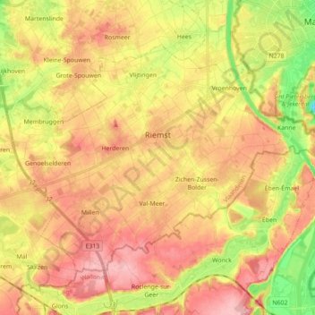
Name: Riemst topographic map, elevation, terrain.

Location: Riemst, Tongeren, Limburg, Flanders, 3770, Belgium (50.76356 5.51354 50.84339 5.68816)

Average elevation: 315 ft

Minimum elevation: 69 ft

Maximum elevation: 502 ft

Other topographic maps

Click on a map to view its topography, its elevation and its terrain.

Veurs

Belgium > Limburg > Tongeren > Sint-Martens-Voeren

Average elevation: 699 ft

Rullekoven

Belgium > Limburg > Tongeren > Borgloon > Kerniel > Rullekoven

Average elevation: 276 ft

Gear up for your next adventure:

📚Navigation Handbooks - Master the art of reading topographic maps and using a compass
💧Water Purification System - Clean water on the trail with reliable purifiers
GPS Sports Watch - GPS watch for running, hiking and training
🥩Freeze-Dried Meals - Nutritious and lightweight food for remote expeditions
🔌Solar Panel Charger - Charge gear sustainably outdoors

As an Amazon Associate, this site earns from qualifying purchases at no extra cost to you.