Villar-d'Arêne topographic map
Interactive map
Click on the map to display elevation.
About this map
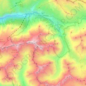
Name: Villar-d'Arêne topographic map, elevation, terrain.
Average elevation: 8,330 ft
Minimum elevation: 4,344 ft
Maximum elevation: 12,904 ft

Click on the map to display elevation.
Name: Villar-d'Arêne topographic map, elevation, terrain.
Average elevation: 8,330 ft
Minimum elevation: 4,344 ft
Maximum elevation: 12,904 ft