Geolocate

Voeren - Fourons topographic map

Click on the map to display elevation.

About this map

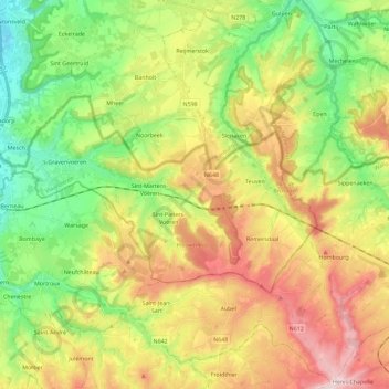
Name: Voeren - Fourons topographic map, elevation, terrain.

Location: Voeren - Fourons, Tongeren, Limburg, Flanders, Belgium (50.70986 5.68217 50.78325 5.91111)

Average elevation: 587 ft

Minimum elevation: 161 ft

Maximum elevation: 1,161 ft

Other topographic maps

Click on a map to view its topography, its elevation and its terrain.

Veurs

Belgium > Limburg > Tongeren > Sint-Martens-Voeren

Average elevation: 699 ft

Rullekoven

Belgium > Limburg > Tongeren > Borgloon > Kerniel > Rullekoven

Average elevation: 276 ft

Gear up for your next adventure:

🔊Portable Camp Speaker - Music and alerts at camp
🧭GPS Watch Accessories - Bands and chargers for GPS watches
📖Nature Tracking Books - Learn to track wildlife and terrain
🪶Fire Starter Kit - Reliable fire starter for survival and camping
🔦LED Headlamp - Bright and durable LED headlamp for night navigation

As an Amazon Associate, this site earns from qualifying purchases at no extra cost to you.