Potrero Cerrado topographic map
Interactive map
Click on the map to display elevation.
About this map
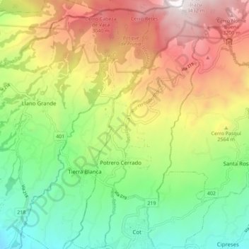
Name: Potrero Cerrado topographic map, elevation, terrain.
Average elevation: 7,717 ft
Minimum elevation: 5,187 ft
Maximum elevation: 11,152 ft

Click on the map to display elevation.
Name: Potrero Cerrado topographic map, elevation, terrain.
Average elevation: 7,717 ft
Minimum elevation: 5,187 ft
Maximum elevation: 11,152 ft