
Martock topographic map
Interactive map
Click on the map to display elevation.
About this map
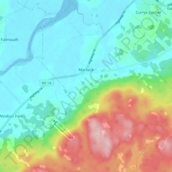
Name: Martock topographic map, elevation, terrain.
Average elevation: 213 ft
Minimum elevation: -7 ft
Maximum elevation: 712 ft
Other topographic maps
Click on a map to view its topography, its elevation and its terrain.
Windsor
Canada > Nova Scotia > Hants County
Windsor, Region of Windsor and West Hants Municipality, Hants County, Nova Scotia, B0N 2T0, Canada
Average elevation: 43 ft
East Walton
Canada > Nova Scotia > Hants County > East Walton
East Walton, East Hants District Municipality, Hants County, Nova Scotia, B0N 2R0, Canada
Average elevation: 112 ft
Scotch Village
Canada > Nova Scotia > Hants County > Scotch Village
Scotch Village, Region of Windsor and West Hants Municipality, Hants County, Nova Scotia, B0N 2G0, Canada
Average elevation: 102 ft
St. Croix
Canada > Nova Scotia > Hants County
St. Croix, Region of Windsor and West Hants Municipality, Hants County, Nova Scotia, B0N 2T0, Canada
Average elevation: 220 ft