
Folkestone and Hythe topographic map
Interactive map
Click on the map to display elevation.
About this map
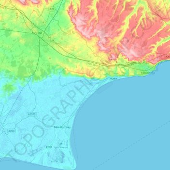
Name: Folkestone and Hythe topographic map, elevation, terrain.
Location: Folkestone and Hythe, Kent, South East, England, United Kingdom (50.91048 0.77684 51.20500 1.22124)
Average elevation: 131 ft
Minimum elevation: -7 ft
Maximum elevation: 627 ft
Other topographic maps
Click on a map to view its topography, its elevation and its terrain.
Lympne
United Kingdom > England > Folkestone and Hythe > Lympne
Lympne, Folkestone and Hythe, Kent, South East, England, CT21 4JG, United Kingdom
Average elevation: 174 ft
Sugarloaf Hill
United Kingdom > England > Folkestone and Hythe
Sugarloaf Hill, Folkestone and Hythe, Kent, South East, England, CT19 6QF, United Kingdom
Average elevation: 295 ft