Geolocate

Choco topographic map

Click on the map to display elevation.

About this map

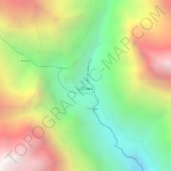
Name: Choco topographic map, elevation, terrain.

Location: Choco, Province of Castilla, Arequipa, Peru (-15.57804 -72.13067 -15.57501 -72.12786)

Average elevation: 9,406 ft

Minimum elevation: 6,926 ft

Maximum elevation: 12,175 ft

Gear up for your next adventure:

🎒Hydration Pack - Hands‑free water reservoir for long hikes
👖Convertible Hiking Pants - Versatile zip-off pants for changing altitudes and temperatures
🕶️GPS Smartphone Mount - Secure mount for phone navigation
🎒Trekking Poles - Sturdy poles for balance and stability on rough terrain
🥩Freeze-Dried Meals - Nutritious and lightweight food for remote expeditions

As an Amazon Associate, this site earns from qualifying purchases at no extra cost to you.