
Demirkazık topographic map
Interactive map
Click on the map to display elevation.
About this map
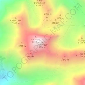
Name: Demirkazık topographic map, elevation, terrain.
Location: Demirkazık, Çamardı, Niğde, İç Anadolu Bölgesi, Turquie (37.83885 35.14805 37.83895 35.14815)
Average elevation: 10,003 ft
Minimum elevation: 7,707 ft
Maximum elevation: 12,211 ft
Other topographic maps
Click on a map to view its topography, its elevation and its terrain.
Emli Vadisi
Emli Vadisi, Çamardı, Niğde, Région de l'Anatolie centrale, Turquie
Average elevation: 7,487 ft