
Village of Cayuga Heights topographic map
Interactive map
Click on the map to display elevation.
About this map
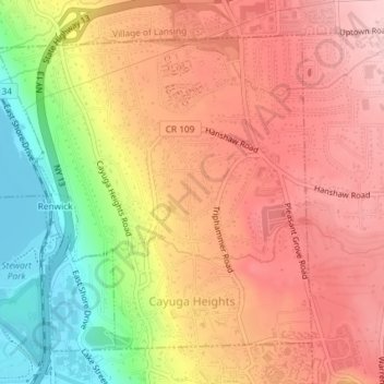
Name: Village of Cayuga Heights topographic map, elevation, terrain.
Average elevation: 768 ft
Minimum elevation: 374 ft
Maximum elevation: 1,020 ft
Cayuga Heights is located at 42°27′59″N 76°29′19″W / 42.466338°N 76.488678°W / 42.466338; -76.488678 (42.466338, -76.488678), on the eastern slope of Cayuga Lake. The elevation ranges from 900 feet near the Community Corners to 400 feet near the lake. Several streams and steep gorges cut through the village.
Other topographic maps
Click on a map to view its topography, its elevation and its terrain.
East Ithaca
United States > New York > Tompkins County > Town of Ithaca
East Ithaca, Town of Ithaca, Tompkins County, New York, United States
Average elevation: 925 ft
Northeast Ithaca
United States > New York > Tompkins County > Town of Ithaca
Northeast Ithaca, Town of Ithaca, Tompkins County, New York, United States
Average elevation: 1,001 ft
Hayts Corner
United States > New York > Tompkins County > Town of Ithaca
Hayts Corner, Town of Ithaca, Tompkins County, New York, 14851, United States
Average elevation: 840 ft