
Make a donation
Gear up for your next adventure:
As an Amazon Associate, this site earns from qualifying purchases at no extra cost to you.
Roxboro topographic map
Click on the map to display elevation.
Make a donation
Gear up for your next adventure:
As an Amazon Associate, this site earns from qualifying purchases at no extra cost to you.
Roxboro
Roxboro receives an average of 7.2 in (183 mm) of snow per winter. Freezing rain and sleet occur most winters, and occasionally the area experiences a major, damaging ice storm. Roxboro is often dubbed the "Snow Capital of the Triangle" because it often receives the most or close to the most snow during snowstorms in central North Carolina due to its high elevation.
Make a donation
Gear up for your next adventure:
As an Amazon Associate, this site earns from qualifying purchases at no extra cost to you.
About this map
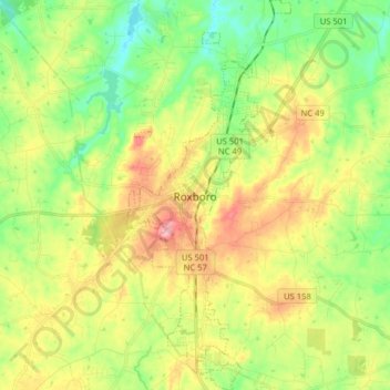
Name: Roxboro topographic map, elevation, terrain.
Location: Roxboro, Person County, North Carolina, 27573, United States (36.33009 -79.01072 36.45819 -78.94375)
Average elevation: 627 ft
Minimum elevation: 440 ft
Maximum elevation: 886 ft
Person County trails, hiking, mountain biking, running and outdoor activities
Make a donation
Gear up for your next adventure:
As an Amazon Associate, this site earns from qualifying purchases at no extra cost to you.
Other topographic maps
Click on a map to view its topography, its elevation and its terrain.
Make a donation
Gear up for your next adventure:
As an Amazon Associate, this site earns from qualifying purchases at no extra cost to you.