
Alburgh topographic map
Interactive map
Click on the map to display elevation.
About this map
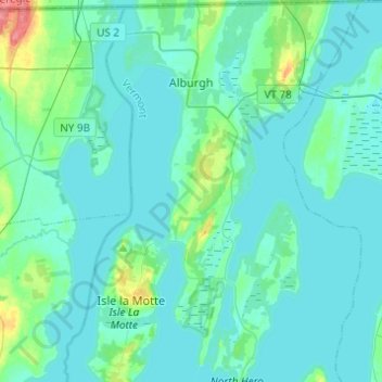
Name: Alburgh topographic map, elevation, terrain.
Location: Alburgh, Grand Isle County, Vermont, 05440, United States (44.83999 -73.35476 45.01342 -73.19234)
Average elevation: 115 ft
Minimum elevation: 89 ft
Maximum elevation: 279 ft
Other topographic maps
Click on a map to view its topography, its elevation and its terrain.
Grand Isle
United States > Vermont > Grand Isle County
Grand Isle, Grand Isle County, Vermont, 05458, United States
Average elevation: 118 ft
South Hero
United States > Vermont > Grand Isle County
South Hero, Grand Isle County, Vermont, 05486, United States
Average elevation: 108 ft
Isle La Motte
United States > Vermont > Grand Isle County
Isle La Motte, Grand Isle County, Vermont, 05463, United States
Average elevation: 115 ft
North Hero
United States > Vermont > Grand Isle County
North Hero, Grand Isle County, Vermont, 05474, United States
Average elevation: 105 ft