Geolocate

McAllen topographic map

Click on the map to display elevation.

About this map

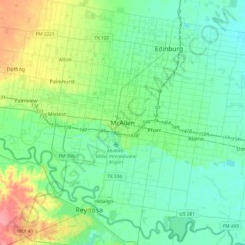
Name: McAllen topographic map, elevation, terrain.

Location: McAllen, Hidalgo County, Texas, 78501, United States (26.04437 -98.39008 26.36437 -98.07008)

Average elevation: 121 ft

Minimum elevation: 69 ft

Maximum elevation: 292 ft

Hidalgo County trails, hiking, mountain biking, running and outdoor activities

Gear up for your next adventure:

🛏️Cold Weather Sleeping Bag - Warm sleeping bag for cold conditions
🥩Freeze-Dried Meals - Nutritious and lightweight food for remote expeditions
🔊Portable Camp Speaker - Music and alerts at camp
📚Navigation Handbooks - Master the art of reading topographic maps and using a compass
🧴Hand Sanitizer - Keep hands clean while hiking

As an Amazon Associate, this site earns from qualifying purchases at no extra cost to you.