
Make a donation
Gear up for your next adventure:
As an Amazon Associate, this site earns from qualifying purchases at no extra cost to you.
Bukhara topographic map
Click on the map to display elevation.
Make a donation
Gear up for your next adventure:
As an Amazon Associate, this site earns from qualifying purchases at no extra cost to you.
Bukhara
About 140 miles (225 km) west of Samarkand in south-central Uzbekistan, Bukhara is located on the Zeravshan River, at an elevation of 751 feet (229 meters).
Make a donation
Gear up for your next adventure:
As an Amazon Associate, this site earns from qualifying purchases at no extra cost to you.
About this map
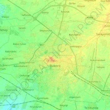
Name: Bukhara topographic map, elevation, terrain.
Location: Bukhara, Bukhara Region, Uzbekistan (39.72317 64.37936 39.82319 64.49997)
Average elevation: 735 ft
Minimum elevation: 702 ft
Maximum elevation: 778 ft
Make a donation
Gear up for your next adventure:
As an Amazon Associate, this site earns from qualifying purchases at no extra cost to you.
Other topographic maps
Click on a map to view its topography, its elevation and its terrain.
Make a donation
Gear up for your next adventure:
As an Amazon Associate, this site earns from qualifying purchases at no extra cost to you.