
Banlieue Bouarada topographic map
Interactive map
Click on the map to display elevation.
About this map
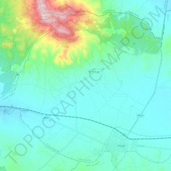
Name: Banlieue Bouarada topographic map, elevation, terrain.
Location: Banlieue Bouarada, Bouaarada, Siliana, Tunisie (36.34149 9.53167 36.42854 9.65248)
Average elevation: 988 ft
Minimum elevation: 650 ft
Maximum elevation: 2,349 ft
Other topographic maps
Click on a map to view its topography, its elevation and its terrain.
Sidi Bou Rouis
Tunisie > Siliana > Sidi Bou Rouis
Sidi Bou Rouis, Bourous Nord, Bourouis, Siliana, 6113, Tunisie
Average elevation: 1,345 ft
Oued el Djedeida
Oued el Djedeida, Sidi Ayed, Aroussa, Siliana, Tunisie
Average elevation: 748 ft