
Make a donation
Gear up for your next adventure:
As an Amazon Associate, this site earns from qualifying purchases at no extra cost to you.
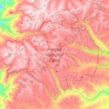
Parque Nacional Cajas topographic map
Click on the map to display elevation.
Make a donation
Gear up for your next adventure:
As an Amazon Associate, this site earns from qualifying purchases at no extra cost to you.
Parque Nacional Cajas
The highest point is the 4,450 m high Cerro Arquitectos (Architects Hill), and the elevation of roads reaches higher than 4,310 meters (13,550 feet). About 270 lakes and lagoons are present in the páramo of Cajas. Luspa is the largest of these lake and extends over 78 hectares with a maximum depth of 68 m at a perimeter of 5,161 m. Like the other lakes it is of glacial origin, and glaciation shaped the landscape of Cajas leaving U-shaped valleys and ravines. Cajas provides about 60% of the drinking water for the Cuenca area. Two of the four rivers of Cuenca originate from Cajas, the Tomebamba and Yanuncay rivers which eventually drain into the Amazon River. The Paute river also links to the Amazon. As the park straddles the continental divide, its western drainage, the Balao and Cañar link to the Pacific ocean. The modern road crosses the continental divide at the pass "Tres Cruces" (4,255 m). This section is the most western part of the continental divide of South America.
Make a donation
Gear up for your next adventure:
As an Amazon Associate, this site earns from qualifying purchases at no extra cost to you.
About this map
Name: Parque Nacional Cajas topographic map, elevation, terrain.
Location: Parque Nacional Cajas, Cuenca, Azuay, Ecuador (-2.95090 -79.38609 -2.74574 -79.14122)
Average elevation: 12,359 ft
Minimum elevation: 7,497 ft
Maximum elevation: 14,810 ft
Make a donation
Gear up for your next adventure:
As an Amazon Associate, this site earns from qualifying purchases at no extra cost to you.
Other topographic maps
Click on a map to view its topography, its elevation and its terrain.
Cuenca
Cuenca, officially Santa Ana de los Ríos de Cuenca, is an Ecuadorian city, head of the canton of the same name and capital of the province of Azuay, as well as its largest and most populated city. It is crossed by the Tomebamba, Tarqui, Yanuncay and Machángara rivers, in the south-central inter-Andean region…
Average elevation: 9,754 ft
Make a donation
Gear up for your next adventure:
As an Amazon Associate, this site earns from qualifying purchases at no extra cost to you.