
Montoito topographic map
Interactive map
Click on the map to display elevation.
About this map
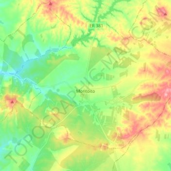
Name: Montoito topographic map, elevation, terrain.
Location: Montoito, Redondo, Évora, Alentejo, Portugal (38.47553 -7.65285 38.55263 -7.51877)
Average elevation: 781 ft
Minimum elevation: 610 ft
Maximum elevation: 1,040 ft
Other topographic maps
Click on a map to view its topography, its elevation and its terrain.
Aldeias de Montoito
Portugal > Évora > Redondo > Montoito > Aldeias de Montoito
Aldeias de Montoito, Montoito, Redondo, Évora, Alentejo, Portugal
Average elevation: 797 ft