
Waikeria topographic map
Interactive map
Click on the map to display elevation.
About this map
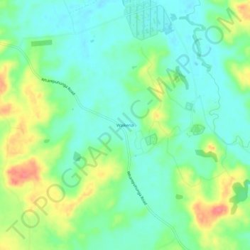
Name: Waikeria topographic map, elevation, terrain.
Location: Waikeria, Otorohanga District, Waikato, 3873, New Zealand (-38.13889 175.36252 -38.09889 175.40252)
Average elevation: 217 ft
Minimum elevation: 135 ft
Maximum elevation: 381 ft
Other topographic maps
Click on a map to view its topography, its elevation and its terrain.
Kawhia
New Zealand > Waikato > Otorohanga District
Kawhia, Otorohanga District, Waikato, 3843, New Zealand
Average elevation: 85 ft
Tihiroa
New Zealand > Waikato > Otorohanga District
Tihiroa, Otorohanga District, Waikato, New Zealand
Average elevation: 289 ft
Ōparau River
New Zealand > Waikato > Otorohanga District
Ōparau River, Otorohanga District, Waikato, New Zealand
Average elevation: 453 ft