
Nakhon Ratchasima topographic map
Interactive map
Click on the map to display elevation.
About this map
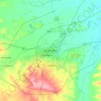
Name: Nakhon Ratchasima topographic map, elevation, terrain.
Average elevation: 640 ft
Minimum elevation: 538 ft
Maximum elevation: 932 ft
Other topographic maps
Click on a map to view its topography, its elevation and its terrain.
Phan Dung
Thailand > Nakhon Ratchasima Province
Phan Dung, Nakhon Ratchasima Province, Thailand
Average elevation: 663 ft
Ban Som
Thailand > Nakhon Ratchasima Province > Ban Som
Ban Som, Nakhon Ratchasima Province, Thailand
Average elevation: 522 ft