
Lambrecht topographic map
Interactive map
Click on the map to display elevation.
About this map
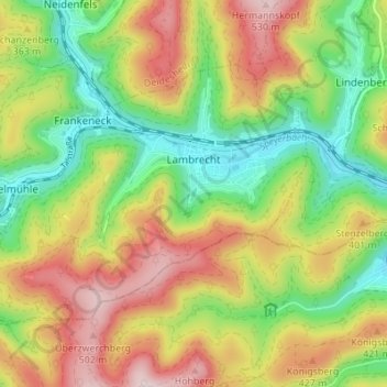
Name: Lambrecht topographic map, elevation, terrain.
Average elevation: 1,066 ft
Minimum elevation: 512 ft
Maximum elevation: 1,752 ft
Other topographic maps
Click on a map to view its topography, its elevation and its terrain.
Friedelsheim
Duitsland > Rijnland-Palts > Landkreis Bad Dürkheim
Friedelsheim, Wachenheim an der Weinstraße, Landkreis Bad Dürkheim, Rijnland-Palts, 67159, Duitsland
Average elevation: 407 ft