
Punch River topographic map
Interactive map
Click on the map to display elevation.
About this map
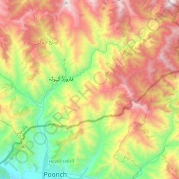
Name: Punch River topographic map, elevation, terrain.
Location: Punch River, Haveli, Haveli District, Azad Kashmir, Pakistan (33.76118 74.06947 33.97837 74.23892)
Average elevation: 6,453 ft
Minimum elevation: 2,992 ft
Maximum elevation: 11,037 ft
Other topographic maps
Click on a map to view its topography, its elevation and its terrain.
Kundal Shahi
Pakistan > Azad Kashmir > Athmuqam Tehsil
Kundal Shahi, Athmuqam Tehsil, Neelam Valley District, Muzaffarabad Division, Azad Kashmir, Pakistan
Average elevation: 5,663 ft
Poonch
Poonch, Poonch District, Azad Kashmir, 12200, Pakistan
Average elevation: 5,410 ft