
Tornavacas topographic map
Interactive map
Click on the map to display elevation.
About this map
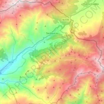
Name: Tornavacas topographic map, elevation, terrain.
Location: Tornavacas, Valle del Jerte, Cáceres, Extremadura, Spain (40.17386 -5.74822 40.29415 -5.61006)
Average elevation: 4,695 ft
Minimum elevation: 1,821 ft
Maximum elevation: 7,841 ft
Other topographic maps
Click on a map to view its topography, its elevation and its terrain.
Jerte
Spain > Extremadura > Valle del Jerte
Jerte, Valle del Jerte, Cáceres, Extremadura, 10612, Spain
Average elevation: 3,970 ft
Casas de Mindaño
Spain > Extremadura > Valle del Jerte > Tornavacas
Casas de Mindaño, Tornavacas, Valle del Jerte, Cáceres, Extremadura, Spain
Average elevation: 4,298 ft