
Christiana topographic map
Interactive map
Click on the map to display elevation.
About this map
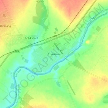
Name: Christiana topographic map, elevation, terrain.
Average elevation: 3,973 ft
Minimum elevation: 3,904 ft
Maximum elevation: 4,052 ft
Other topographic maps
Click on a map to view its topography, its elevation and its terrain.
Bloemhof
South Africa > North West > Dr Ruth Segomotsi Mompati District Municipality > Lekwa-Teemane Local Municipality
Bloemhof, Lekwa-Teemane Local Municipality, Dr Ruth Segomotsi Mompati District Municipality, North West, 2660, South Africa
Average elevation: 4,049 ft