
Les Saillants du Gua topographic map
Interactive map
Click on the map to display elevation.
About this map
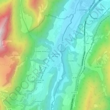
Name: Les Saillants du Gua topographic map, elevation, terrain.
Average elevation: 2,047 ft
Minimum elevation: 1,066 ft
Maximum elevation: 4,377 ft
Other topographic maps
Click on a map to view its topography, its elevation and its terrain.
Mont Gerbier
France > Auvergne-Rhône-Alpes > Isère > Le Gua
Mont Gerbier, Le Gua, Grenoble, Isère, Auvergne-Rhône-Alpes, France métropolitaine, 38450, France
Average elevation: 5,161 ft
Prélenfrey
France > Auvergne-Rhône-Alpes > Isère > Le Gua
Prélenfrey, Le Gua, Grenoble, Isère, Auvergne-Rhône-Alpes, France métropolitaine, 38450, France
Average elevation: 3,442 ft
Saint-Barthélémy du Gua
France > Auvergne-Rhône-Alpes > Isère > Le Gua
Saint-Barthélémy du Gua, Le Gua, Grenoble, Isère, Auvergne-Rhône-Alpes, France métropolitaine, 38450, France
Average elevation: 2,431 ft
Les Grands Amieux
France > Auvergne-Rhône-Alpes > Isère > Le Gua
Les Grands Amieux, Le Gua, Grenoble, Isère, Auvergne-Rhône-Alpes, France métropolitaine, 38450, France
Average elevation: 2,215 ft
L'Échaillon
France > Auvergne-Rhône-Alpes > Isère > Le Gua
L'Échaillon, Le Gua, Grenoble, Isère, Auvergne-Rhône-Alpes, France métropolitaine, 38450, France
Average elevation: 2,598 ft