
Pedro Juan Caballero topographic map
Interactive map
Click on the map to display elevation.
About this map
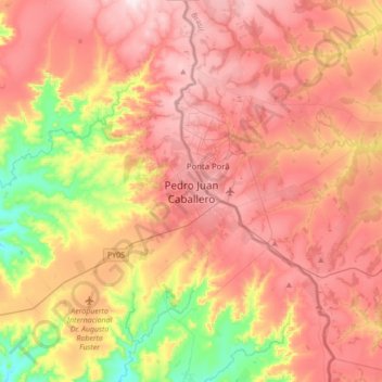
Name: Pedro Juan Caballero topographic map, elevation, terrain.
Average elevation: 1,827 ft
Minimum elevation: 1,060 ft
Maximum elevation: 2,408 ft
La ciudad de Pedro Juan Caballero se halla asentada en una meseta de la Cordillera del Amambay, a unos 700 metros sobre el nivel del mar. La topografía del terreno se presenta sin accidentes considerables, presentando un aspecto agradable con suaves ondulaciones.
Other topographic maps
Click on a map to view its topography, its elevation and its terrain.
Río Ypané
Paraguay > Amambay > Pedro Juan Caballero
Río Ypané, Pedro Juan Caballero, Amambay, Región Oriental, Paraguay
Average elevation: 663 ft
General Genes
Paraguay > Amambay > Pedro Juan Caballero
General Genes, Pedro Juan Caballero, Amambay, Región Oriental, Paraguay
Average elevation: 2,051 ft