
Kastraki topographic map
Interactive map
Click on the map to display elevation.
About this map
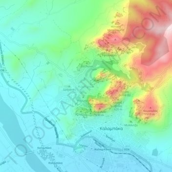
Name: Kastraki topographic map, elevation, terrain.
Average elevation: 1,076 ft
Minimum elevation: 643 ft
Maximum elevation: 2,211 ft
Other topographic maps
Click on a map to view its topography, its elevation and its terrain.
Μετέωρα
Griechenland > Thessalien - Mittelgriechenland > Regionalbezirk Trikala > Kastraki
Μετέωρα, Kastraki, Δήμος Μετεώρων, Regionalbezirk Trikala, Region Thessalien, Thessalien - Mittelgriechenland, 422 00, Griechenland
Average elevation: 1,407 ft