
Ghilassa topographic map
Interactive map
Click on the map to display elevation.
About this map
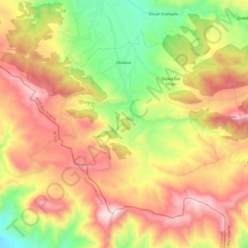
Name: Ghilassa topographic map, elevation, terrain.
Location: Ghilassa, Daïra Bordj Ghedir, Bordj Bou Arreridj, Algérie (35.81102 4.84493 35.88430 4.96412)
Average elevation: 4,636 ft
Minimum elevation: 3,156 ft
Maximum elevation: 6,004 ft