
Make a donation
Gear up for your next adventure:
As an Amazon Associate, this site earns from qualifying purchases at no extra cost to you.
Chesières topographic map
Click on the map to display elevation.
Make a donation
Gear up for your next adventure:
As an Amazon Associate, this site earns from qualifying purchases at no extra cost to you.
About this map
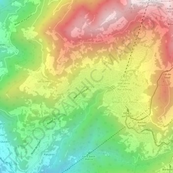
Name: Chesières topographic map, elevation, terrain.
Location: Chesières, Ollon, District d'Aigle, Vaud, 1885, Switzerland (46.28129 7.02258 46.32129 7.06258)
Average elevation: 4,091 ft
Minimum elevation: 2,139 ft
Maximum elevation: 6,302 ft
Make a donation
Gear up for your next adventure:
As an Amazon Associate, this site earns from qualifying purchases at no extra cost to you.
Other topographic maps
Click on a map to view its topography, its elevation and its terrain.
Gryon
Switzerland > Vaud > District d'Aigle
The municipality is located in the Aigle district, on a narrow terrace at an elevation of 1,110 m (3,640 ft) between the Gryonne and Avançon canyons. To the east lie the hillside settlements of Les Chaux and La Barboleusaz (or Barboleuse). In the north are forests and the alpine pasture of Taveyanne. The…
Average elevation: 4,068 ft
Gryon
Switzerland > Vaud > District d'Aigle
The municipality is located in the Aigle district, on a narrow terrace at an elevation of 1,110 m (3,640 ft) between the Gryonne and Avançon canyons. The commune is composed of multiple settlements, which include the Gryon village, Barboleuse, Alpe des Chaux, Taveyanne, and Peuffeyre. In the western part…
Average elevation: 4,068 ft
Leysin
Switzerland > Vaud > District d'Aigle
The municipality is located in the Aigle district, on the right side of the Grande-Eau at the foot of the Tour d'Aï and the Tour de Mayen. The main village is located at an elevation of 1,260 m (4,130 ft). It consists of the village of Leysin and the hamlets of Veyges, Feydey, Aï, and Mayen.
Average elevation: 4,436 ft
Make a donation
Gear up for your next adventure:
As an Amazon Associate, this site earns from qualifying purchases at no extra cost to you.
Make a donation
Gear up for your next adventure:
As an Amazon Associate, this site earns from qualifying purchases at no extra cost to you.