
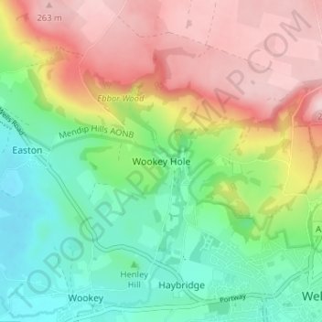
Wookey Hole topographic map
Interactive map
Click on the map to display elevation.
About this map
Name: Wookey Hole topographic map, elevation, terrain.
Average elevation: 397 ft
Minimum elevation: 20 ft
Maximum elevation: 899 ft
Other topographic maps
Click on a map to view its topography, its elevation and its terrain.
Oldford
United Kingdom > England > Somerset > Mendip District > Frome
Oldford, Berkley, Frome, Mendip District, Somerset, England, BA11 2NG, United Kingdom
Average elevation: 269 ft
Coleford
United Kingdom > England > Somerset > Mendip District
Coleford, Mendip District, Somerset, England, United Kingdom
Average elevation: 476 ft
Hemington
United Kingdom > England > Somerset > Mendip District > Faulkland
Hemington, Faulkland, Mendip District, Somerset, England, United Kingdom
Average elevation: 394 ft
Huxham Green
United Kingdom > England > Somerset > Mendip District > East Pennard
Huxham Green, East Pennard, Mendip District, Somerset, England, BA4 6RR, United Kingdom
Average elevation: 213 ft
Faulkland
United Kingdom > England > Somerset > Mendip District
Faulkland, Mendip District, Somerset, England, BA3 5WH, United Kingdom
Average elevation: 407 ft
Berkley
United Kingdom > England > Somerset > Mendip District
Berkley, Mendip District, Somerset, England, United Kingdom
Average elevation: 276 ft
Pennard Hill
United Kingdom > England > Somerset > Mendip District
Pennard Hill, Mendip District, Somerset, England, BA4 6UG, United Kingdom
Average elevation: 236 ft
Midway
United Kingdom > England > Somerset > Mendip District > Stoke St. Michael > Midway
Midway, Stoke St Michael, Stoke St. Michael, Mendip District, Somerset, England, BA3 5JE, United Kingdom
Average elevation: 715 ft
St. Michael's Tower
United Kingdom > England > Somerset > Mendip District > Glastonbury
St. Michael's Tower, Stone Down Lane, Glastonbury, Mendip District, Somerset, South West England, England, BA6 9, United Kingdom
Average elevation: 108 ft
Upton Noble
United Kingdom > England > Somerset > Mendip District
Upton Noble, Mendip District, Somerset, England, United Kingdom
Average elevation: 495 ft
Stratton on the Fosse
United Kingdom > England > Somerset > Mendip District
Stratton on the Fosse, Mendip District, Somerset, England, United Kingdom
Average elevation: 558 ft
Oxenpill
United Kingdom > England > Somerset > Mendip District > Meare
Oxenpill, Meare, Mendip District, Somerset, England, BA6 9TY, United Kingdom
Average elevation: 16 ft
Chewton Mendip
United Kingdom > England > Somerset > Mendip District
Chewton Mendip, Mendip District, Somerset, England, United Kingdom
Average elevation: 633 ft
West Lydford
United Kingdom > England > Somerset > Mendip District > Lydford-on-Fosse
West Lydford, Lydford-on-Fosse, Mendip District, Somerset, England, TA11 7ET, United Kingdom
Average elevation: 102 ft