
Thank you for supporting this site ❤️
Make a donation
Make a donation
Gear up for your next adventure:
As an Amazon Associate, this site earns from qualifying purchases at no extra cost to you.
Gersfeld topographic map
Click on the map to display elevation.
Thank you for supporting this site ❤️
Make a donation
Make a donation
Gear up for your next adventure:
As an Amazon Associate, this site earns from qualifying purchases at no extra cost to you.
About this map
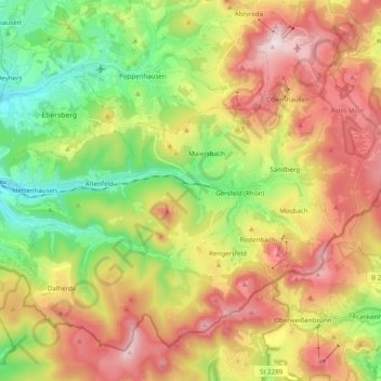
Name: Gersfeld topographic map, elevation, terrain.
Location: Gersfeld, Landkreis Fulda, Hesse, 36129, Germany (50.39750 9.80091 50.50299 9.99711)
Average elevation: 2,119 ft
Minimum elevation: 1,227 ft
Maximum elevation: 3,127 ft
Thank you for supporting this site ❤️
Make a donation
Make a donation
Gear up for your next adventure:
As an Amazon Associate, this site earns from qualifying purchases at no extra cost to you.