
ไทรโยค topographic map
Interactive map
Click on the map to display elevation.
About this map
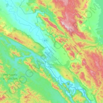
Name: ไทรโยค topographic map, elevation, terrain.
Location: ไทรโยค, Kanchanaburi, Thaïlande (14.29451 98.70185 14.61451 99.02185)
Average elevation: 1,106 ft
Minimum elevation: 184 ft
Maximum elevation: 3,323 ft
Other topographic maps
Click on a map to view its topography, its elevation and its terrain.
Kanchanaburi
Kanchanaburi, ปากแพรก, Kanchanaburi, 71000, Thaïlande
Average elevation: 151 ft
สังขละบุรี
สังขละบุรี, Kanchanaburi, 71240, Thaïlande
Average elevation: 676 ft