
Make a donation
Gear up for your next adventure:
As an Amazon Associate, this site earns from qualifying purchases at no extra cost to you.
Worms topographic map
Click on the map to display elevation.
Make a donation
Gear up for your next adventure:
As an Amazon Associate, this site earns from qualifying purchases at no extra cost to you.
About this map
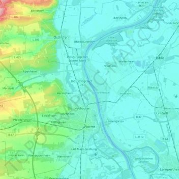
Name: Worms topographic map, elevation, terrain.
Location: Worms, Rhineland-Palatinate, Germany (49.58631 8.23797 49.73634 8.44641)
Average elevation: 344 ft
Minimum elevation: 272 ft
Maximum elevation: 732 ft
Make a donation
Gear up for your next adventure:
As an Amazon Associate, this site earns from qualifying purchases at no extra cost to you.
Other topographic maps
Click on a map to view its topography, its elevation and its terrain.
Leimersdorf
Germany > Rhineland-Palatinate > Landkreis Ahrweiler > Grafschaft
Average elevation: 669 ft
Make a donation
Gear up for your next adventure:
As an Amazon Associate, this site earns from qualifying purchases at no extra cost to you.
Zimmet
Germany > Rhineland-Palatinate > Landkreis Bernkastel-Wittlich > Piesport
Average elevation: 607 ft
Burg Hohlenfels
Germany > Rhineland-Palatinate > Rhein-Lahn-Kreis > Mudershausen
Average elevation: 925 ft
Make a donation
Gear up for your next adventure:
As an Amazon Associate, this site earns from qualifying purchases at no extra cost to you.
Ramstein-Miesenbach
Germany > Rhineland-Palatinate > Landkreis Kaiserslautern > Ramstein-Miesenbach > Ramstein-Miesenbach
Average elevation: 853 ft
Weinfelder Maar
Germany > Rhineland-Palatinate > Landkreis Vulkaneifel > Schalkenmehren
Average elevation: 1,532 ft
Make a donation
Gear up for your next adventure:
As an Amazon Associate, this site earns from qualifying purchases at no extra cost to you.