
Bardez topographic map
Click on the map to display elevation.
About this map
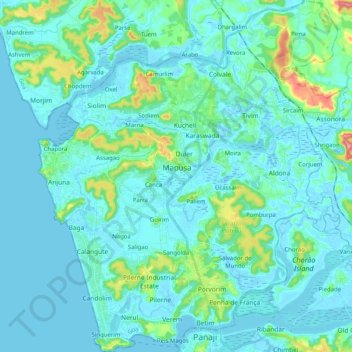
Name: Bardez topographic map, elevation, terrain.
Location: Bardez, North Goa, Goa, India (15.49010 73.73186 15.68535 73.91074)
Average elevation: 72 ft
Minimum elevation: -10 ft
Maximum elevation: 541 ft
Other topographic maps
Click on a map to view its topography, its elevation and its terrain.
Mapusa
Mapusa is located at 15°36′N 73°49′E / 15.60°N 73.82°E / 15.60; 73.82. It has an average elevation of 15 metres (49 feet).It lies on the banks of Mapusa River. Mapusa has a tropical climate with temperatures ranging from a high of 37 °C in summer with high levels of humidity to a low of 21 °C in winters.
Average elevation: 85 ft