
Sligo Municipal Borough District topographic map
Interactive map
Click on the map to display elevation.
About this map
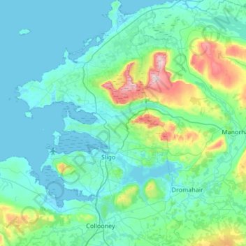
Name: Sligo Municipal Borough District topographic map, elevation, terrain.
Average elevation: 285 ft
Minimum elevation: -10 ft
Maximum elevation: 2,103 ft
Other topographic maps
Click on a map to view its topography, its elevation and its terrain.
Belclare
Belclare, Aclare ED, Ballymote-Tubbercurry Municipal District, County Sligo, Connacht, Ireland
Average elevation: 417 ft
Ballincar
Ballincar, Drumcliff West ED, Sligo Municipal Borough District, County Sligo, Connacht, Ireland
Average elevation: 52 ft
Sligo
Sligo, Sligo Municipal Borough District, County Sligo, Connacht, Ireland
Average elevation: 69 ft