
Kalamazoo topographic map
Interactive map
Click on the map to display elevation.
About this map
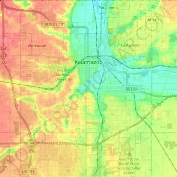
Name: Kalamazoo topographic map, elevation, terrain.
Location: Kalamazoo, Kalamazoo County, Michigan, United States (42.21556 -85.66271 42.33275 -85.53078)
Average elevation: 869 ft
Minimum elevation: 745 ft
Maximum elevation: 1,007 ft
Kalamazoo County trails, hiking, mountain biking, running and outdoor activities
Other topographic maps
Click on a map to view its topography, its elevation and its terrain.