
Gadilam River topographic map
Interactive map
Click on the map to display elevation.
About this map
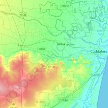
Name: Gadilam River topographic map, elevation, terrain.
Average elevation: 95 ft
Minimum elevation: -10 ft
Maximum elevation: 315 ft
Other topographic maps
Click on a map to view its topography, its elevation and its terrain.
Cuddalore
India > Tamil Nadu > Cuddalore
Cuddalore, Cuddalore district, Tamil Nadu, 607002, India
Average elevation: 26 ft
Puduppalayam
India > Tamil Nadu > Cuddalore > Puduppalayam
Puduppalayam, Cuddalore, Cuddalore District, Tamil Nadu, 607001, India
Average elevation: 16 ft