
Selman topographic map
Interactive map
Click on the map to display elevation.
About this map
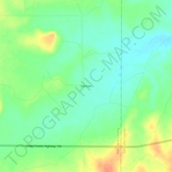
Name: Selman topographic map, elevation, terrain.
Location: Selman, McCulloch County, Texas, United States (31.23378 -99.12116 31.27378 -99.08116)
Average elevation: 1,565 ft
Minimum elevation: 1,506 ft
Maximum elevation: 1,657 ft
Other topographic maps
Click on a map to view its topography, its elevation and its terrain.
Mercury
United States > Texas > McCulloch County
Mercury, McCulloch County, Texas, United States
Average elevation: 1,424 ft
Rochelle
United States > Texas > McCulloch County
Rochelle, McCulloch County, Texas, 76872, United States
Average elevation: 1,775 ft
Brady
United States > Texas > McCulloch County > Brady > Brady
Brady, McCulloch County, Texas, 76825, United States
Average elevation: 1,739 ft
Brady
United States > Texas > McCulloch County
Brady, McCulloch County, Texas, 76825, United States
Average elevation: 1,755 ft
Voca
United States > Texas > McCulloch County
Voca, McCulloch County, Texas, 76887, United States
Average elevation: 1,549 ft