
Wilhelmsthal topographic map
Interactive map
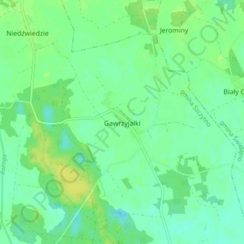
Click on the map to display elevation.
About this map
Name: Wilhelmsthal topographic map, elevation, terrain.
Average elevation: 446 ft
Minimum elevation: 423 ft
Maximum elevation: 476 ft
Other topographic maps
Click on a map to view its topography, its elevation and its terrain.
Kallenau
Polen > Woiwodschaft Ermland-Masuren > powiat szczycieński
Kallenau, Gemeinde Mensguth, powiat szczycieński, Woiwodschaft Ermland-Masuren, 12-120, Polen
Average elevation: 512 ft
Neuenwalde
Polen > Woiwodschaft Ermland-Masuren > powiat szczycieński
Neuenwalde, gmina Wielbark, powiat szczycieński, Woiwodschaft Ermland-Masuren, 12-160, Polen
Average elevation: 423 ft
Wacholderau
Polen > Woiwodschaft Ermland-Masuren > powiat szczycieński
Wacholderau, gmina Wielbark, powiat szczycieński, Woiwodschaft Ermland-Masuren, 12-160, Polen
Average elevation: 407 ft
Ingelheim
Polen > Woiwodschaft Ermland-Masuren > powiat szczycieński > Kallenczin
Ingelheim, Kallenczin, gmina Dźwierzuty, powiat szczycieński, Woiwodschaft Ermland-Masuren, 12-120, Polen
Average elevation: 522 ft