
Make a donation
Gear up for your next adventure:
As an Amazon Associate, this site earns from qualifying purchases at no extra cost to you.
Thamsbrück topographic map
Click on the map to display elevation.
Make a donation
Gear up for your next adventure:
As an Amazon Associate, this site earns from qualifying purchases at no extra cost to you.
Thamsbrück
Thamsbrück is located in the west of the Thuringian Basin about 4 kilometres (2.5 mi) north of Bad Langensalza at an altitude of 175 metres (574 ft) above NHN. The surrounding area is agricultural. On the southern and western edge of the village, the Unstrut, with two river courses, flows eastwards to the Saale. The Welsbach, which comes from the north, flows into the Unstrut on the north-west side of the village.
Make a donation
Gear up for your next adventure:
As an Amazon Associate, this site earns from qualifying purchases at no extra cost to you.
About this map
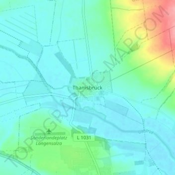
Name: Thamsbrück topographic map, elevation, terrain.
Average elevation: 620 ft
Minimum elevation: 561 ft
Maximum elevation: 863 ft
Make a donation
Gear up for your next adventure:
As an Amazon Associate, this site earns from qualifying purchases at no extra cost to you.