
Pathankot topographic map
Interactive map
Click on the map to display elevation.
About this map
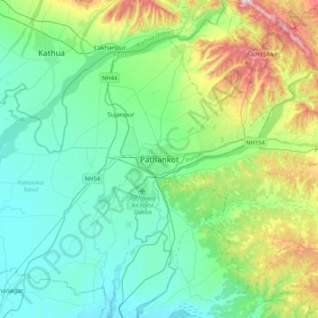
Name: Pathankot topographic map, elevation, terrain.
Average elevation: 1,243 ft
Minimum elevation: 843 ft
Maximum elevation: 2,566 ft
Pathankot has an average elevation of 332 metres (1,089 ft). It is a green town surrounded by the Ravi and Chakki rivers. Shiwalik foothills on the south and east and snow-capped Himalayas in the back drop in north.
Other topographic maps
Click on a map to view its topography, its elevation and its terrain.
Sujanpur
India > Punjab > Pathankot Tahsil
Sujanpur, Pathankot Tahsil, Pathankot district, Punjab, 145023, India
Average elevation: 1,096 ft