
Dolly Sods Wilderness topographic map
Interactive map
Click on the map to display elevation.
About this map
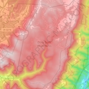
Name: Dolly Sods Wilderness topographic map, elevation, terrain.
Average elevation: 3,415 ft
Minimum elevation: 1,138 ft
Maximum elevation: 4,432 ft
Other topographic maps
Click on a map to view its topography, its elevation and its terrain.
Maysville
United States > West Virginia > Grant County
Maysville, Grant County, West Virginia, 26833, United States
Average elevation: 1,555 ft
Scherr
United States > West Virginia > Grant County
Scherr, Grant County, West Virginia, United States
Average elevation: 1,932 ft
Bayard
United States > West Virginia > Grant County
Bayard, Grant County, West Virginia, United States
Average elevation: 2,602 ft
Cabins
United States > West Virginia > Grant County
Cabins, Grant County, West Virginia, 26855, United States
Average elevation: 1,286 ft
Lahmansville
United States > West Virginia > Grant County
Lahmansville, Grant County, West Virginia, 26731, United States
Average elevation: 1,289 ft
Medley
United States > West Virginia > Grant County
Medley, Grant County, West Virginia, 26731, United States
Average elevation: 1,283 ft
Dorcas
United States > West Virginia > Grant County
Dorcas, Grant County, West Virginia, United States
Average elevation: 1,161 ft
Arthur
United States > West Virginia > Grant County
Arthur, Grant County, West Virginia, United States
Average elevation: 1,306 ft
Wilson
United States > West Virginia > Grant County
Wilson, Grant County, West Virginia, 27267, United States
Average elevation: 2,703 ft
Mount Storm
United States > West Virginia > Grant County
Mount Storm, Grant County, West Virginia, 26739, United States
Average elevation: 2,736 ft
Gormania
United States > West Virginia > Grant County
Gormania, Grant County, West Virginia, 26720, United States
Average elevation: 2,615 ft
Bismarck
United States > West Virginia > Grant County
Bismarck, Grant County, West Virginia, 26739, United States
Average elevation: 3,035 ft
Petersburg
United States > West Virginia > Grant County
Petersburg, Grant County, West Virginia, 26847, United States
Average elevation: 991 ft