
Santa Marta do Bouro topographic map
Interactive map
Click on the map to display elevation.
About this map
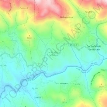
Name: Santa Marta do Bouro topographic map, elevation, terrain.
Location: Santa Marta do Bouro, Amares, Braga, 4720-633, Portugal (41.63728 -8.31023 41.67728 -8.27023)
Average elevation: 643 ft
Minimum elevation: 108 ft
Maximum elevation: 1,759 ft